Tolkien’s Middle Earth mapped to Europe
Some 45 years ago when I first read Tolkien, I recall making (or trying to make) a relief map of Middle Earth on cardboard with crumpled paper and glue and paint and plasticene for the relief features. I never had the patience to get it quite finsished and it was too large to survive my many moves as a student. But maps and cartography have fascinated ever since.
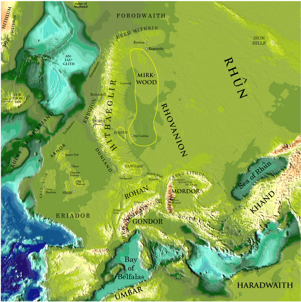
I have just come across this map of Middle Earth which – I think – is about 10 years old. Peter Bird is Professor Emeritus at the Department of Earth, Planetary, and Space Sciences of UCLA and this map of Tolkien’s Middle Earth is from his personal page. Here he superimposes Middle Earth onto a Europe at a time when sea levels (in my estimation) were more than 100m lower than they are today. All very fanciful of course, but interesting and for me very nostalgic.
From Frank Jacobs at strange maps:
But, as Tolkien states in the prologue to ‘The Lord of the Rings’, it would be fruitless to look for geographical correspondences, as “Those days, the Third Age of Middle-earth, are now long past, and the shape of all lands has been changed…” And yet, that’s exactly what Peter Bird attempts with the map here shown. Bird, a professor of Geophysics and Geology at UCLA, has overlapped the map of Middle-earth with one of Europe, which leads to following locations:
- The Shire is in the South-West of England, which further north is also home to the Old Forest (Yorkshire?), the Barrow Downs (north of England), the city of Bree (at or near Newcastle-upon-Tyne) and Amon Sul (Scottish Highlands).
- The Grey Havens are situated in Ireland.
- Eriador corresponds with Brittany.
- Helm’s Deep is near the Franco-German-Swiss border tripoint, close to the city of Basel.
- The mountain chain of Ered Nimrais is the Alps.
- Gondor corresponds with the northern Italian plains, extended towards the unsubmerged Adriatic Sea.
- Mordor is situated in Transylvania, with Mount Doom in Romania (probably), Minas Morgul in Hungary (approximately) and Minas Tirith in Austria (sort of).
- Rohan is in southern Germany, with Edoras at the foot of the Bavarian Alps. Also in Germany, but to the north, near present-day Hamburg, is Isengard. Close by is the forest of Fangorn.
- To the north is Mirkwood, further east are Rhovanion and the wastes of Rhûn, close to the Ural mountains.
- The Sea of Rhûn corresponds to the Black Sea.
- Khand is Turkey
- Haradwaith is the eastern part of North Africa, Umbar corresponds with the Maghreb, the western part of North Africa.
- The Bay of Belfalas is the western part of the Mediterranean.

Middle Earth by Peter Bird
Allowing for polar wander and sea level change, most sites are recognizable. The southern Hithaeglir and northern Ephel Duath have sunk, unless perhaps they were only illusions that have been dispelled.
A civil engineer with a longlife fondness for Software Libero